Walking
the Hodder - Stage 2
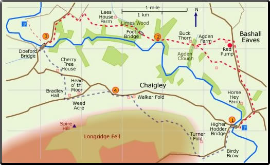
Higher Hodder Bridge to Doeford Bridge
Distance 9.12 miles : time about 4 hours
<Stage 1  Stage
2 Stage 3 >
Stage
2 Stage 3 >
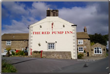
is a fine old hostelry dating from 1756 offering a selection of local beers and home cooked local food.
Closed Mondays and Tuesdays:
see the website for opening times.
Stage 2: Higher Hodder Bridge to Doeford
Bridge
Please note that since this route was first described some paths have become overgrown. Parts of the walk may now be found to be too difficult.
 Walk
up the hill past Hodder Cottages, turn left at the cross roads.
Continue along the road, the FP starts on the left just after the
Y-junction.
Walk
up the hill past Hodder Cottages, turn left at the cross roads.
Continue along the road, the FP starts on the left just after the
Y-junction.
(Alternatively continue to The Red Pump Inn after which the FP starts 50 yds up the road. Turn left into the farm road and follow the waymarkers through the farm yard. The path is now well waymarked over stiles and fields to Aigden Farm. (35 min))
Shortly after the small pond take the stile on the right and walk across the field to the stile just left of the tall ash tree. Follow the hedge on the right to the stile under the large holly tree. Again follow the hedge on the right to the next stile. Walk across the field to the plank footbridge and follow the fence on the left to the double gate. A stile is seen to the right of the gate; the path leads to Aigden Farm. Go through the farm yard and look for the path on the left just after the last barn. The path now crosses Aigden Clough by a series of wood steps. On leaving the Clough the path passes in front of Buck Thorn and way markers point the way across the field to the next stile. Paper Mill Wood is directly ahead. After a stile the path goes steeply down hill by a series of wooden steps to the Hodder bank side. (70 min)
 The
path now follows close to the Hodder. After the ladder stile,
walk diagonally up the escarpment on the right. Crossing this
high ground with the Hodder far below leads to the entrance of
the Limes Wood Conservation Area. Carry straight on over the
foot bridge and the over the next bridge high above Mill Brook.
After a pleasant woodland walk, the path emerges at a stile and
continues in an almost straight line over a series of fields
and stiles. The path ends at a farm track. Turn left and then
right to meet the main road. At the road turn left and walk to
Doeford Bridge. (65 min)
The
path now follows close to the Hodder. After the ladder stile,
walk diagonally up the escarpment on the right. Crossing this
high ground with the Hodder far below leads to the entrance of
the Limes Wood Conservation Area. Carry straight on over the
foot bridge and the over the next bridge high above Mill Brook.
After a pleasant woodland walk, the path emerges at a stile and
continues in an almost straight line over a series of fields
and stiles. The path ends at a farm track. Turn left and then
right to meet the main road. At the road turn left and walk to
Doeford Bridge. (65 min)
 The
FP continues at a ladder stile 40 yd on the left after the Bridge.
Bear left to the wood side and look for a plank foot bridge.
Follow the hedge on the right over a series of fields to the
barn. At the barn turn right to the main road. Walk to Cherry
Tree House; the FP start on the right. Walk diagonally across
the field to the stile and carry on to Bradley Hall. Just before
the house the FP diverts to the right through the cottages; turn
left at the road. Continue along the road to the entrance to
Rakefoot. The FP is found a few yards after the entrance and
follows an old wooded path direct to what was the Craven Heifer
pub which is now permanently closed. (45 min)
The
FP continues at a ladder stile 40 yd on the left after the Bridge.
Bear left to the wood side and look for a plank foot bridge.
Follow the hedge on the right over a series of fields to the
barn. At the barn turn right to the main road. Walk to Cherry
Tree House; the FP start on the right. Walk diagonally across
the field to the stile and carry on to Bradley Hall. Just before
the house the FP diverts to the right through the cottages; turn
left at the road. Continue along the road to the entrance to
Rakefoot. The FP is found a few yards after the entrance and
follows an old wooded path direct to what was the Craven Heifer
pub which is now permanently closed. (45 min)
 Continue
along the road to Walker Fold; the start of the FP is seen on
the right. The path ascends the very steep grassy fellside and
meets with the path going along Longridge Fell. Turn left and
follow this well-defined forest path (white waymarkers) which
ends at Birdy Brow. Turn left at the road; a steep descent leads
to Higher Hodder Bridge. (60 min)
Continue
along the road to Walker Fold; the start of the FP is seen on
the right. The path ascends the very steep grassy fellside and
meets with the path going along Longridge Fell. Turn left and
follow this well-defined forest path (white waymarkers) which
ends at Birdy Brow. Turn left at the road; a steep descent leads
to Higher Hodder Bridge. (60 min)
(Alternatively continue to The Red Pump Inn after which the FP starts 50 yds up the road. Turn left into the farm road and follow the waymarkers through the farm yard. The path is now well waymarked over stiles and fields to Aigden Farm. (35 min))
Shortly after the small pond take the stile on the right and walk across the field to the stile just left of the tall ash tree. Follow the hedge on the right to the stile under the large holly tree. Again follow the hedge on the right to the next stile. Walk across the field to the plank footbridge and follow the fence on the left to the double gate. A stile is seen to the right of the gate; the path leads to Aigden Farm. Go through the farm yard and look for the path on the left just after the last barn. The path now crosses Aigden Clough by a series of wood steps. On leaving the Clough the path passes in front of Buck Thorn and way markers point the way across the field to the next stile. Paper Mill Wood is directly ahead. After a stile the path goes steeply down hill by a series of wooden steps to the Hodder bank side. (70 min)