190117
The Haweswater Reservoir was constructed in 1919 to provide
water for the city of Manchester. Although man-made the reservoir
can be regarded as the most easterly of all the lakes in the
Lake District. Set in the middle of the Eastern Fells, Haweswater
is easily accessible from the M6. The route from J39 goes through
Shap, on to Bampton, and then to the hamlet of Burnbanks at
the top of the reservoir.
The present walk follows the banks of Haweswater for 9 miles; the circular path ensures that the walker cannot get lost and is guaranteed to finish at the starting point! The photo album shows the weather when the walk was last undertaken: late autumn, blue sky, sun shine all day, and no wind. The perfect conditions for any walk. It is best to start the walk from Burnbanks; this ensures that the walker gets the sun on the western side of the water in the morning and then enjoys the sunshine once again in the afternoon on the eastern shore.
The Haweswater Hotel is the only building to be encountered on the walk except for the water piers nearby. Thankfully the Hotel caters for walkers. The hotel is open all day for drinks, meals and snacks.
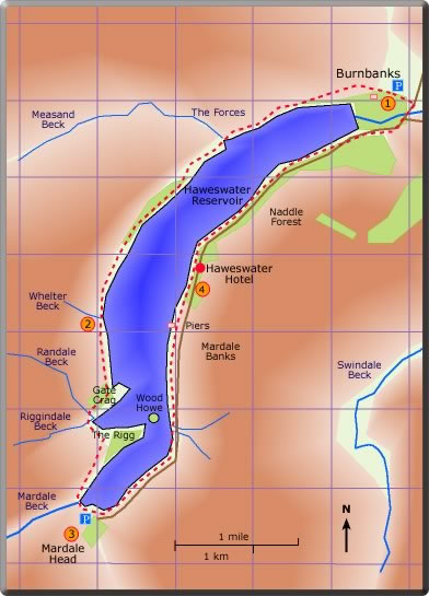
A circular walk around Haweswater
Distance 10.38 miles: time requires about 5 hours
< previous
walk walk 1 next
walk >
walk 1 next
walk >
Haweswater Hotel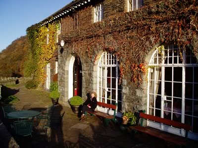 Enjoying the sunshine in the late afternoon
Enjoying the sunshine in the late afternoonA steady climb uphill leads to the fell side with a wood of tall trees on the left. Haweswater soon comes into view and then the high dam. Once on the right track there is little more to be said regarding the path. From Burnbanks to Upper Mardale the path is straight forward; all the walker needs do is enjoy the changing land- and water-scape.
After half an hour The Forces Waterfall is the first main feature to be crossed, it is the first of many becks that feed the reservoir. (1 hr 20 min)
On continuing the prominent Gate Crag and The Rigg come into view. After such a dry summer the reservoir was very low so there was little water at the Mardale Head end of the reservoir. This gave the opportunity for the drowned field system with the long lost stone walls to be observed.
After the FB over Riggindale Beck the path continues between short standing stones.
The FB over Mardale Beck leads around to the car park. (1 hr 10 min)
When this walk was last completed (January 2019), the Shore FP was closed, so our route back to the Haweswater Hotel was along the road.
(total time 4 hr 30 min).