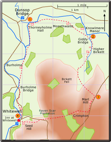
A circular walk from Dunsop
Bridge to Whitewell
distance 6.75 (7.5) mile : time 3 hours
< previous
walk walk
6 next
walk >
walk
6 next
walk >
(It has been reported that a number of trees have fallen over in the wood and a little sense of adventure is required to negotiate these obstacles.)
Go through the wood and over the ladder stile into pasture land. The path to Whitewell lies straight ahead. Keep to the left of Raven Scar Plantation and go over the ladder stile encountered about 100 yd before the road. Cross the road, and continue downhill. Close to Whitewell go through the gate, keep to the right of the house on Seed Hill and to the left of the stone wall of St Michael's Burial Ground. A small wooden gate leads onto the road close to the Inn.
(50 min)
 For the return
to Dunsop Bridge find the path behind the stone wall on the left
just after the Inn. A concessionary footpath leads around the farm
and avoids using the very narrow road; the path then rejoins the
road to Burholme Bridge. Just before the bridge the route follows
a farm track to Burholme Farm. Go through the farmyard, turn left,
go over the footbridge and carry straight on. The walk is completed
with a pleasant stroll along the bank of the Hodder to the bridge
leading to Thorneyholme Hall. Turn left over the bridge to the
car park in Dunsop Bridge. (50min)
For the return
to Dunsop Bridge find the path behind the stone wall on the left
just after the Inn. A concessionary footpath leads around the farm
and avoids using the very narrow road; the path then rejoins the
road to Burholme Bridge. Just before the bridge the route follows
a farm track to Burholme Farm. Go through the farmyard, turn left,
go over the footbridge and carry straight on. The walk is completed
with a pleasant stroll along the bank of the Hodder to the bridge
leading to Thorneyholme Hall. Turn left over the bridge to the
car park in Dunsop Bridge. (50min) A circular
walk from Dunsop Bridge to Whitewell
 From the car
park in Dunsop Bridge walk across the road and down the drive to
Thorneyholme Hall; the FP starts across the bridge on the left.
At the end of the wall turn right into the field and walk in the
direction of the electricity poles. Go over the stile, bear right
and aim for a gap in the stone wall in the distance. Go through
the gap and follow the concessionary footpath along a grassy path
to Mossthwaite. A farm track then continues by Knowlmere Manor
and on to Giddy Bridge. (30 min)
From the car
park in Dunsop Bridge walk across the road and down the drive to
Thorneyholme Hall; the FP starts across the bridge on the left.
At the end of the wall turn right into the field and walk in the
direction of the electricity poles. Go over the stile, bear right
and aim for a gap in the stone wall in the distance. Go through
the gap and follow the concessionary footpath along a grassy path
to Mossthwaite. A farm track then continues by Knowlmere Manor
and on to Giddy Bridge. (30 min)(The walk now goes over the open fell. In wet weather the ground can be a little boggy. And the path may not be too obvious.)
Over the stile bear left and look for a waymarker. A gentle walk downhill leads to a lone alder tree by Birkett Brook. After the brook bear left up the steep bank and keep to the high ground. The path is not too well defined but take a compass bearing and walk south east. The steady walk uphill leads to the top of the gully. Over the gully a waymarker points to a stile and the path continues to the road just to the left of the barn at Marl Hill House. (40 min)
![]() Inn at Whitewell
Inn at Whitewell
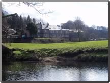
Open all day but see the website for more info.
The
Inn at Whitewell as seen from
the Hodder bank.
the Hodder bank.
This walk is typical of some those offered in this series; a combination of a fell and a river walk. The first part of the walk from Dunsop Bridge to Giddy Bridge is a pleasant stroll through fields and park land. There then follow a climb past Higher Birkett to Birkett Fell and on towards Marl Hill.
From Crimpton to Whitewell there is a welcome descent through pasture land and woodland.
The Inn at Whitewell is a popular venue for drinks and lunches now open all day.
On the return from Whitewell the narrow road can be partially avoided by using the concessionary FP found on the left. The final leg mainly along the Hodder is a not too strenuous river walk.