The River Hodder
is a dominant feature in the Forest of Bowland landscape. From
its source high above Stocks Reservoir to its confluence with
the Ribble two miles east of Hurst Green, the Hodder is a delight
to the walker and fisherman alike. The river is a valuable wild
life resource; grayling is the main catch in the upper Hodder,
while brown trout is found in the lower reaches. The months
of May to July see the run of sea trout, while September and
October bring the salmon. Water fowl can be seen along the length
of the river and the stalking heron is often disturbed.
As the crow flies the distance from Slaidburn to Hurst Green
is 9 miles, the Hodder however meanders some 19.5 miles from Stocks Reservoir
until it meets the Ribble.
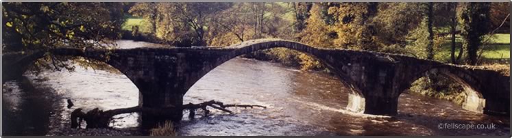
The Lower Hodder between Higher and Lower Hodder Bridges marks the historical county boundary between Lancashire and Yorkshire.
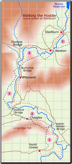
The object of this series of
walks is to explore the Hodder from Hurst Green in the south
to Slaidburn or Stocks Reservoir in the north. It is not possible to follow the
banks of the Hodder wholly along public footpaths, so some diversion
has to be made. The route has been divided into 5 stages; each
stage made into a circular walk with a pub as a possible objective.
The completion of these stages enables the whole of the Hodder
to be explored.
Walk details for each stage can
be found by clicking the respective link below or on the map.
It is essential to use
the O.S map for each walk which may be printed off from the respective web page.
Stage
1 - from Hurst Green to Higher
Hodder Bridge.
 Starting
at the Shireburn Arms in Hurst Green the walk initially follows the Ribble and then meets
the Hodder as it enters the Ribble. The walk continues to High Hodder Bridge and returns
to Hurst Green via Stonyhurst College.
Starting
at the Shireburn Arms in Hurst Green the walk initially follows the Ribble and then meets
the Hodder as it enters the Ribble. The walk continues to High Hodder Bridge and returns
to Hurst Green via Stonyhurst College.
Stage
2 - from Higher Hodder Bridge
to Doeford Bridge
Please note that since this route was first described some paths have become overgrown. Parts of the walk may now be found to be too difficult.
The return
leg passes the former Craven Heifer at Chaigley and thereafter the
steep climb up and along Longridge Fell.
Stage
3 - from Doeford Bridge to Burholme Bridge
The Inn
at Whitewell is encountered here on the banks of the Hodder.
Stage
4 - from Burholme Bridge to Newton
There
is no pub in Dunsop Bridge but the Parkers Arms in Newton makes
for a popular
half-way
house.
Stage
5 - from Newton to Slaidburn and beyond
The short
walk from Newton to the Hark to Bounty in Slaidburn can be extended
to take in Stocks Reservoir.
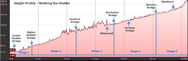
The plot
shows the height profile for the River Hodder starting at its confluence with the River Ribble on the left and its exit from Stocks Reservoir top right. The water falls through 135 m/443 feet over its meandering course of 19.5 miles. The 5 stages described in the walks above and points of interest along the River are shown on the diagram.
The plot was produced using Google Maps Pro.
The name Hodder is likely derived from
Brythonic. Its meaning is either "pleasant stream" or possibly "boundary"
(
Welsh yr odre), the latter suggesting that the Lancashire/Yorkshire border has its origins in the depths of antiquity. It is thought that
Bowland takes its name from the Old Norse
boga- meaning a bow in a river; the Hodder being characterised by the way it meanders and twists through the Bowland landscape.
River Hodder Ref.:Wikipedia®