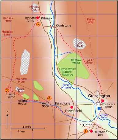
A circular walk in Wharfedale from Linton to Kilnsey
Distance:
10.10 miles; time required about 4 hours 30 minutes
< previous
walk walk 7 next
walk >
walk 7 next
walk >
After refreshment at the Tennant Arms the walk continues along Mastiles Lane, an old Roman road, and across the moorland with panoramic views to the east over Wharfedale. A further example of the exposed limestone is seen at Cave Scar after which a gentle descent leads back across lush meadowland to Linton.
![]() From
Linton follow the signs to Linton Parish Church/Linton Falls.
At the Falls go over the footbridge and up the walled Sedber
Lane. Turn left at the car park and follow the signs to Town
Centre. After the Devonshire Arms and Foresters Arms turn
left up Chapel Street and then right up Bank Lane; follow
the signs to the Dales Way. On leaving Grassington the path
passes over a series of fields and stiles before reaching
the open moor. (50 min)
From
Linton follow the signs to Linton Parish Church/Linton Falls.
At the Falls go over the footbridge and up the walled Sedber
Lane. Turn left at the car park and follow the signs to Town
Centre. After the Devonshire Arms and Foresters Arms turn
left up Chapel Street and then right up Bank Lane; follow
the signs to the Dales Way. On leaving Grassington the path
passes over a series of fields and stiles before reaching
the open moor. (50 min)
Soon after the path diverges from the Dales Way. The path now follows closely the beautiful stone wall on the edge of Bastow Wood and through the ancient field
system at Lea Green. Walk towards the limestone escarpment
of Dib Scar seen to the north.
At the top edge of the wood go through the double wooden gate and follow the stone wall now on the right. A fairly steep descent takes the walker to a small gate in the stone wall. Now follow the wall on the left.
At the end of the wall the path become very narrow and follows the contour along the steep escarpment.
Two waymarkers point up the incline. A gentle descent now follows through a series of gates taking the walker into Conistone. Kilnsey Crag is seen in the distance.
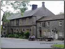
Walk through the village to the road bridge over the Wharfe. At the squeezer stile follow
the FP sign to Kilnsey Crag. Turn left at the road for the
Tennant Arms. (1hr 15min)
![]() Walk
up the road by the side of the pub. After about 600 yds take
the left-hand fork along the gravel track following Mastiles
Lane to Malham Tarn. On passing the field system and just
before the gate across the track the path bears left between
two stone walls to a gate (0.8 miles from the pub). After about 200 yd take the grassy
path on the left uphill away from the dead straight wall and
wire fence on the right. Blue waymarkers lead the way steadily
uphill along the wide grassy track. After a gate the path
continues again following the blue waymarkers to the road, with Cave Scar seen on the left. Continue over the road to
to Height Laithe. Look for the stile and path on the left
to Wood Nook. (50 min)
Walk
up the road by the side of the pub. After about 600 yds take
the left-hand fork along the gravel track following Mastiles
Lane to Malham Tarn. On passing the field system and just
before the gate across the track the path bears left between
two stone walls to a gate (0.8 miles from the pub). After about 200 yd take the grassy
path on the left uphill away from the dead straight wall and
wire fence on the right. Blue waymarkers lead the way steadily
uphill along the wide grassy track. After a gate the path
continues again following the blue waymarkers to the road, with Cave Scar seen on the left. Continue over the road to
to Height Laithe. Look for the stile and path on the left
to Wood Nook. (50 min)
![]() Go
through the farmyard and continue for 20 yds up hill. Turn sharp left at the gate. The path descends through meadowland following
yellow waymarkers and goes past the derelict Height House. The path continues to and through the camping site at Wood Nook and on to the road. (35 min)
Go
through the farmyard and continue for 20 yds up hill. Turn sharp left at the gate. The path descends through meadowland following
yellow waymarkers and goes past the derelict Height House. The path continues to and through the camping site at Wood Nook and on to the road. (35 min)
![]() Turn
right at the road and then left into Skirethorns. Walk through
the village and find the stile on the right signposted to
Threshfield. The path goes over a series of meadows. On reaching the last field bear left towards the house seen at the top left hand corner of the field. Cross the road and
continue to Linton. The path emerges opposite the village
green and the Fontaine Inn. (35 min)
Turn
right at the road and then left into Skirethorns. Walk through
the village and find the stile on the right signposted to
Threshfield. The path goes over a series of meadows. On reaching the last field bear left towards the house seen at the top left hand corner of the field. Cross the road and
continue to Linton. The path emerges opposite the village
green and the Fontaine Inn. (35 min)